
Drainage Basins
Antarctica and Greenland Ice Sheet Drainage Basins
For the IMBIE 2026-2027 regional assessment, we are aiming at producing reconciled time-series of mass changes for the 18 drainage basins of Antarctica and 7 sectors of Greenland (see details below). The definition of drainage basins is very important to produce regional assessment of mass balance and assess differences between techniques; therefore all participants are requested to post their results using these sets of drainage basins. The drainage basins delineations can be downloaded below (as a shapefile or as masks stored in a netCDF files).
A note on peripheral glaciers and ice caps:
Following discussions with the glacier community, we have updated the peripheral glaciers and ice caps delineations to be used. The ice sheet delineations are derived from Rignot et al. (2011) and Mouginot et al. (2019) for the Antarctic and Greenland ice sheets, respectively and where applicable, the peripheral glaciers and ice caps delineations are based on the Randolph Glacier Inventory (RGI, version 7.0).
Please note that you can choose to submit mass balance estimates for the ice sheet only, for the peripheral glaciers and ice caps only, and/or for the ice sheet and peripheral glaciers and ice caps together (please refer to the Mass Balance Submission Guide[IO1] for more details).
IMBIE AIS Regional Delineations
We are using the delineations from Rignot et al. (2011), which divide Antarctica into the West Antarctic Ice Sheet (WAIS), the East Antarctic Ice Sheet (EAIS) and the Antarctic Peninsula Ice Sheet (APIS) based on historical definitions, modern-day DEM and ice velocity data. APIS is limited by Ronne to the east and George VI to the west. WAIS and EAIS are divided along the Transantarctic range; WAIS drains into Ronne, EAIS drains into Filchner. The basin boundaries are defined with a posting of ~ 150m. Within these three ice sheet regions, 18 drainage basins (named A-Ap, Ap-B, B-C, C-Cp, Cp-D, D-Dp, Dp-E, E-Ep, Ep-F, F-G, G-H, H-Hp, Hp-I, I-Ipp, Ipp-J, J-Jpp, Jpp-K, K-A) are defined based on historical nomenclature (Giovinetto and Zwally, 2000) plus modern DEM and ice velocity data, and adjusted to match the drainage boundaries of the major ice shelves. Grounding lines, area, ice fronts of all ice shelves are based on Rignot et al. (2013). The interior basins rely on an ERS/ICESat DEM in the interior and the 2011 velocity mosaic (flow direction) near the coast. The basins are close to an earlier definition (Rignot et al., 2011) where no area is left out, and hence can be used for altimetry, gravity and mass-budget alike. Grounding lines are InSAR 2011 (NSIDC). For the peripheral glaciers and ice caps, both the islands defined in Rignot et al. (2011) and the glaciers mapped by the Randolph Glacier Inventory (RGI v7.0, 2023) that are located within approximately 300 km of the main ice sheet are included.
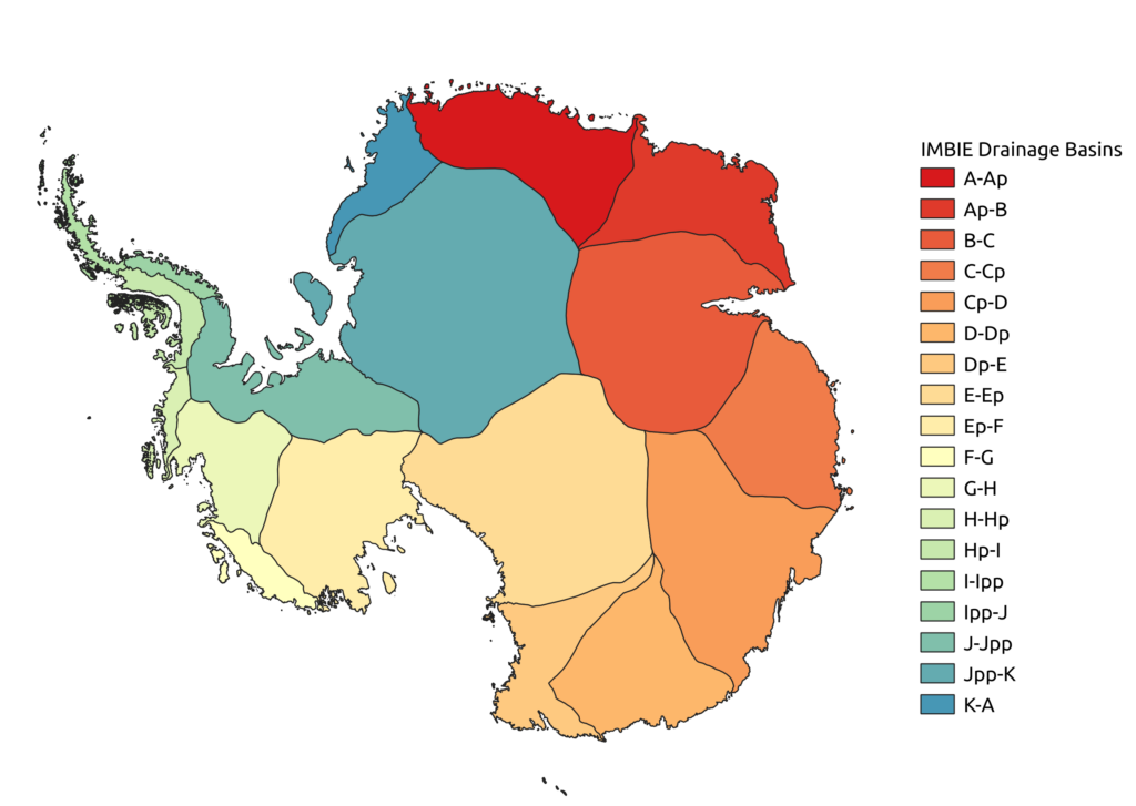
IMBIE AIS Regional Delineations
Data download for AIS Regional Delineations
Reference
- Giovinetto, M.B. and H.J. Zwally, 2000. Spatial distribution of net surface accumulation on the Antarctic ice sheet. Annals of Glaciology, 31, 171-178, DOI: 10.3189/172756400781820200
- Rignot, E., J. Mouginot, and B. Scheuchl, 2011. Antarctic Grounding Line Mapping from Differential Satellite Radar Interferometry, Geophysical Research Letters, 38, L10504, DOI: 10.1029/2011GL047109
- Rignot, E., S. Jacobs, J. Mouginot, and B. Scheuchl, 2013. Ice Shelf Melting Around Antarctica. Science, 341(6143): 266-270. DOI: 10.1126/science.1235798
- RGI 7.0 Consortium, 2023. Randolph Glacier Inventory – A Dataset of Global Glacier Outlines, Version 7.0. Boulder, Colorado USA. NSIDC: National Snow and Ice Data Center. doi:10.5067/f6jmovy5navz. Online access: https://doi.org/10.5067/f6jmovy5navz https://doi.org/10.5067/f6jmovy5navz
IMBIE GRIS Regional Delineations
We are using the drainage basin definitions defined by Mouginot & Rignot (2019), which divide the Greenland ice sheet into 7 regions (named South West (SW), Central West (CW), North West (NW), North (NO), North East (NE), Central East (CE), and South East (SE)) based on ice flow direction and surface slope using a composite velocity mosaic from Mouginot et al. (2017) and surface slope from GIMP DEM (Howat et al., 2014). These regions are separated based on glacier regime (marine-terminating dominance versus land-terminating) and SMB (dry vs wet) and are of comparable size and ice production. For the peripheral glaciers and ice caps falling outside of the ice sheet definition from Mouginot & Rignot (2019), we are using the Randolph Glacier Inventory (RGI v7.0, 2023) delineations.
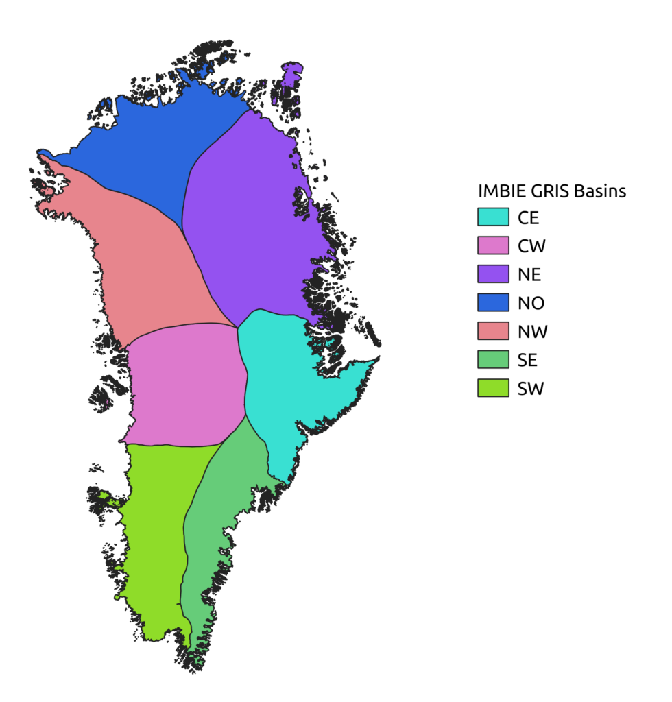
IMBIE GrIS Regional Delineations
Data download for GrIS Regional Delineations
Reference
- Mouginot J, Rignot E, Scheuchl B, Millan R (2017) Comprehensive annual ice sheet velocity mapping using landsat-8, sentinel-1, and radarsat-2 data. Remote Sensing, 9(4), DOI: 10.3390/rs9040364
- Howat IM, Negrete A, Smith BE (2014) The greenland ice mapping project (gimp) land classification and surface elevation data sets. The Cryosphere, 8(4):1509–1518, DOI: 10.5194/tc-8-1509-2014
- Mouginot J, Rignot E (2019). Glacier catchments/basins for the Greenland Ice Sheet [Dataset]. Dryad. DOI: 10.7280/D1WT11
- RGI 7.0 Consortium, 2023. Randolph Glacier Inventory – A Dataset of Global Glacier Outlines, Version 7.0. Boulder, Colorado USA. NSIDC: National Snow and Ice Data Center. doi:10.5067/f6jmovy5navz. Online access: https://doi.org/10.5067/f6jmovy5navz https://doi.org/10.5067/f6jmovy5navz