Antarctica and Greenland Ice Sheet Drainage Basins
IMBIE 2016 uses two sets of grounded ice area and drainage basin definitions for Antarctica and Greenland. The first set, mapped by Zwally et al., (2012), were used in IMBIE 2012 and are retained for consistency. The second set, mapped by rignot et al. (2016), are an updated definition introduced here for the first time. All participants are required to post their results on both sets of drainage basins.
Zwally Basins
The maps were created using surface elevation data derived from ICESat, with the drainage basins delineated based on ice provenance. The definitions include 27 basins in Antarctica and 19 basins in Greenland that cover areas of 12,377,790 km² and 1.722.572 km², respectively. In Antarctica, the East and West Antarctic Ice Sheets (EAIS and WAIS, respectively) are separated approximately along the Trans-Antarctic Mountains, with the EAIS divided into 16 basins, the WAIS into seven and the Antarctic Peninsula into four. The 19 basins in Greenland are grouped into eight separate regions (1=North, 2=North-East, 3=East, 4=South-East, 5=South, 6=South-West, 7=West, 8=North-West). These delineations are shown in the figures below.
Drainage basin and ice sheet outlines in lat/lon vector format can be downloaded from the following links:
Zwally Antarctic Drainage Basins
Zwally Greenland Drainage Basins
If required, further information on these drainage basin definitions may be found at:
http://icesat4.gsfc.nasa.gov/cryo_data/ant_grn_drainage_systems.php
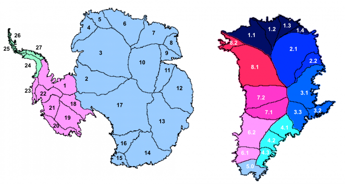
Antarctica (left) and Greenland (right) drainage basin and ice sheet definitions, produced by Zwally et al., (2012) and used by IMBIE 2016
Reference
- Zwally, H. Jay, Mario B. Giovinetto, Matthew A. Beckley, and Jack L. Saba, 2012, Antarctic and Greenland Drainage Systems, GSFC Cryospheric Sciences Laboratory, at http://icesat4.gsfc.nasa.gov/cryo_data/ant_grn_drainage_systems.php.
Rignot Basins
Antarctica is separated into WAIS, EAIS and AP based on historical definitions plus information from modern-day DEM and ice velocity data. AP is limited by Ronne to the east and George VI to the west. WAIS and EAIS are divided along the Transantarctic range; WAIS drains into Ronne, EAIS drains into Filchner. The basin boundaries are defined with a posting of ~ 150m. Within these three ice sheet regions, subregions A, B, C, Cp, etc. are defined based on historical nomenclature (Giovinetto and Zwally, 2000) plus modern DEM and ice velocity data, and adjusted to match the drainage boundaries of the major ice shelves. Grounding lines, area, ice fronts of all ice shelves are based on (Rignot et al., 2013). The interior basins rely on an ERS/ICESat DEM in the interior and the 2011 velocity mosaic (flow direction) near the coast. The basins are close to an earlier definition (Rignot et al., 2011a) where no area is left out, and hence can be used for altimetry, gravity and mass-budget alike. Grounding lines are InSAR 2011 (NSIDC). Surrounding glaciers and ice caps are in one separate shape file. Sub-sub-divisions are not included at this stage.
Greenland ice drainage units are based on historical usage (Rignot et al., 2011b). The regions are separated based on glacier regime (marine-terminating dominance versus land-terminating) and SMB (dry vs wet). NW and CW has a clear basin boundary near Rinks. CW to SW marks the transition from tidewater to land-terminating. SE vs NE is at a major transition in SMB with a well-defined divide inland. Our delineation uses the GIMP DEM, and an ice velocity data set (Rignot and Mouginot, 2012). All surrounding ice caps and glaciers are in one shape file “islands”. Ice margin is from GIMP. Sub-sub-divisions are not included.
Rignot Antarctic Drainage Basins
Rignot Greenland Drainage Basins
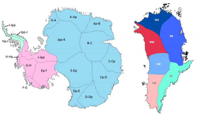
Antarctica (left) and Greenland (right) drainage basin and ice sheet definitions, produced by E. Rignot and J. Mouginot and used by IMBIE 2016.
References
- Giovinetto, M.B. and H.J. Zwally, 2000. Spatial distribution of net surface accumulation on the Antarctic ice sheet. Annals of Glaciology, 31, 171-178.
- Rignot, E., J. Mouginot, and B. Scheuchl, 2011a. Antarctic Grounding Line Mapping from Differential Satellite Radar Interferometry, Geophysical Research Letters, 38, L10504, DOI: 10.1029/2011GL047109
- Rignot, E., Velicogna, I., Van Den Broeke, M. R., Monaghan, A., Lenaerts, J., 2011b. Acceleration of the contribution of the Greenland and Antarctic ice sheets to sea level rise, Geophysical Research Letters, 38 (5), art. no. L05503, DOI: 10.1029/2011GL046583
- Rignot, E., Mouginot, J., 2012. Ice flow in Greenland for the International Polar Year 2008-2009, Geophysical Research Letters, 39 (11), art. no. L11501. DOI: 10.1029/2012GL051634
- Rignot, E., S. Jacobs, J. Mouginot, and B. Scheuchl, 2013. Ice Shelf Melting Around Antarctica. Science, 341(6143): 266-270. DOI: 10.1126/science.1235798